File:DoorCountyLocator.png
Jump to navigation
Jump to search


Size of this preview: 800 × 388 pixels. Other resolution: 918 × 445 pixels.
Original file (918 × 445 pixels, file size: 96 KB, MIME type: image/png)
Summary[edit | edit source]
go ahead, expand the image, though do be noted I have your address registered. Oh wait, THIS IS THE SUMMARY, NOT WHERE I THREATEN USERS! MY BAD
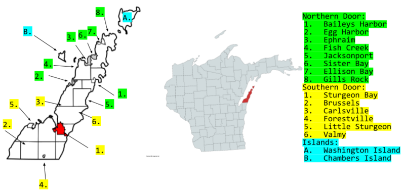
Anyways, This map basically highlights the relevant areas of Door County where tourists might flock to in Northern Door County, and where tourists might harass the natives in Southern Door County.
Licensing[edit | edit source]
This file is licensed under the Do What The Fuck You Want To Public License (WTFPL), version 2. You have the right to do what the fuck you want to this file and its source model. However, if there is no source model distributed along with this file or this file's source model is based on the source model of something else that is neither unlicensed nor under the Do What The Fuck You Want To Public License, then this file is probably not under the Do What The Fuck You Want To Public License and the {{WTFPL}} tag should be removed.
File history
Click on a date/time to view the file as it appeared at that time.
| Date/Time | Thumbnail | Dimensions | User | Comment | |
|---|---|---|---|---|---|
| current | 13:53, 30 March 2025 |  | 918 × 445 (96 KB) | DeltaPotato (talk | contribs) | go ahead, expand the image, though do be noted I have your address registered. Oh wait, THIS IS THE SUMMARY, NOT WHERE I THREATEN USERS! MY BAD Anyways, This map basically highlights the relevant areas of Door County where tourists might flock to in Northern Door County, and where tourists might harass the natives in Southern Door County. |
You cannot overwrite this file.
File usage
The following page uses this file: