File:Mount Shasta as seen from Highway 97-2920.jpg

Original file (5,742 × 3,589 pixels, file size: 14.31 MB, MIME type: image/jpeg)
![]() |
This is a file from Wikimedia Commons. Information from its description page there is shown below.
Commons is a freely licensed media file repository. You can help, but they'd probably rather you didn't. |
Summary
DescriptionMount Shasta as seen from Highway 97-2920.jpg |
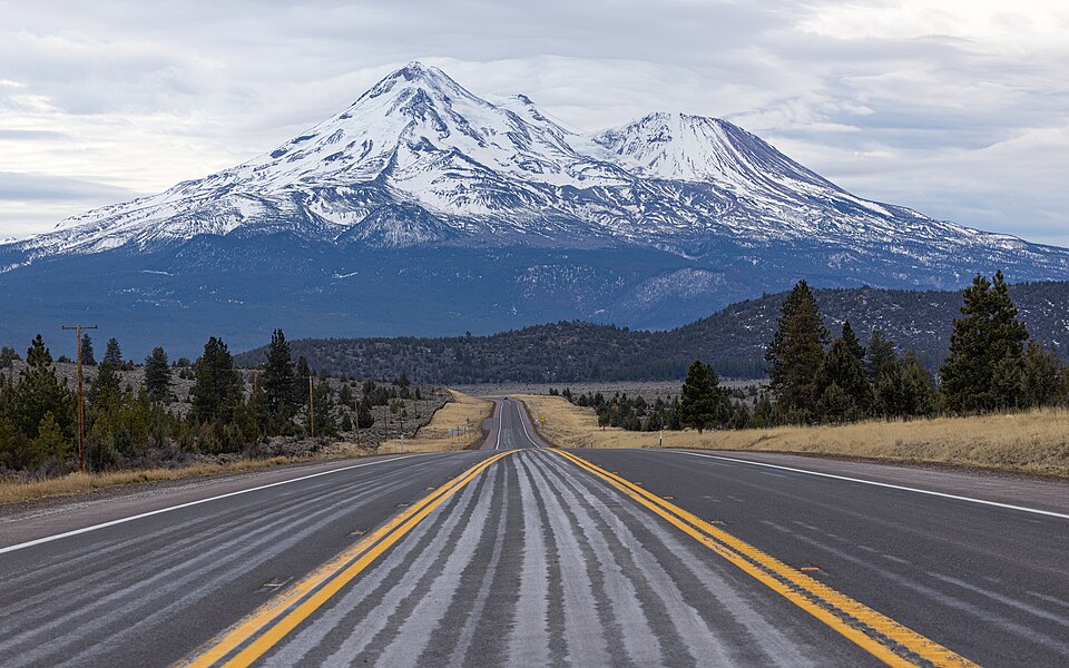
English: Volcano Mount Shasta in Northern California as seen from Highway 97 between Weed and Dorris |
Date | |
Source | Own work |
Author | Frank Schulenburg |
Camera location | 41° 37′ 01.05″ N, 122° 12′ 03.24″ W ![]() | View this and other nearby images on: OpenStreetMap | ![]() |
---|
Licensing


- You are free:
- to share – to copy, distribute and transmit the work
- to remix – to adapt the work
- Under the following conditions:
- attribution – You must give appropriate credit, provide a link to the license, and indicate if changes were made. You may do so in any reasonable manner, but not in any way that suggests the licensor endorses you or your use.
- share alike – If you remix, transform, or build upon the material, you must distribute your contributions under the same or compatible license as the original.
![]() |
This image has been assessed using the Quality image guidelines and is considered a Quality image.
العربية ∙ جازايرية ∙ беларуская ∙ беларуская (тарашкевіца) ∙ български ∙ বাংলা ∙ català ∙ čeština ∙ Cymraeg ∙ Deutsch ∙ Schweizer Hochdeutsch ∙ Zazaki ∙ Ελληνικά ∙ English ∙ Esperanto ∙ español ∙ eesti ∙ euskara ∙ فارسی ∙ suomi ∙ français ∙ galego ∙ עברית ∙ हिन्दी ∙ hrvatski ∙ magyar ∙ հայերեն ∙ Bahasa Indonesia ∙ italiano ∙ 日本語 ∙ Jawa ∙ ქართული ∙ Qaraqalpaqsha ∙ 한국어 ∙ kurdî ∙ кыргызча ∙ Latina ∙ Lëtzebuergesch ∙ lietuvių ∙ македонски ∙ മലയാളം ∙ मराठी ∙ Bahasa Melayu ∙ Nederlands ∙ Norfuk / Pitkern ∙ polski ∙ português ∙ português do Brasil ∙ rumantsch ∙ română ∙ русский ∙ sicilianu ∙ slovenčina ∙ slovenščina ∙ shqip ∙ српски / srpski ∙ svenska ∙ தமிழ் ∙ తెలుగు ∙ ไทย ∙ Tagalog ∙ toki pona ∙ Türkçe ∙ українська ∙ oʻzbekcha / ўзбекча ∙ vèneto ∙ Tiếng Việt ∙ 中文 ∙ 中文(简体) ∙ 中文(繁體) ∙ +/− |
Captions
Items portrayed in this file
depicts
30 January 2022
41°37'1.049"N, 122°12'3.240"W
0.008 second
10
79 millimetre
400
image/jpeg
15,007,138 byte
3,589 pixel
5,742 pixel
a29d6e7caf9699407fde0608e9a3ff89ee0cb9ae
File history
Click on a date/time to view the file as it appeared at that time.
Date/Time | Thumbnail | Dimensions | User | Comment | |
---|---|---|---|---|---|
current | 04:37, 31 January 2022 | ![]() | 5,742 × 3,589 (14.31 MB) | wikimediacommons>Frank Schulenburg | Uploaded own work with UploadWizard |
File usage
The following page uses this file:
Metadata
This file contains additional information, probably added from the digital camera or scanner used to create or digitize it.
If the file has been modified from its original state, some details may not fully reflect the modified file.
Camera manufacturer | Canon |
---|---|
Camera model | Canon EOS R3 |
Author | Frank Schulenburg |
Exposure time | 1/125 sec (0.008) |
F Number | f/10 |
ISO speed rating | 400 |
Date and time of data generation | 16:27, 30 January 2022 |
Lens focal length | 79 mm |
Latitude | 41° 37′ 1.05″ N |
Longitude | 122° 12′ 3.24″ W |
Altitude | 1,498.5 meters above sea level |
Copyright holder |
|
Horizontal resolution | 240 dpi |
Vertical resolution | 240 dpi |
Software used | Adobe Photoshop Lightroom Classic 11.1 (Macintosh) |
File change date and time | 19:37, 30 January 2022 |
Exposure Program | Aperture priority |
Exif version | 2.31 |
Date and time of digitizing | 16:27, 30 January 2022 |
APEX shutter speed | 6.965784 |
APEX aperture | 6.643856 |
APEX exposure bias | 0 |
Maximum land aperture | 4 APEX (f/4) |
Metering mode | Pattern |
Flash | Flash did not fire |
DateTimeOriginal subseconds | 64 |
DateTimeDigitized subseconds | 64 |
Color space | sRGB |
Focal plane X resolution | 1,669.8765869141 |
Focal plane Y resolution | 1,669.8765869141 |
Focal plane resolution unit | 3 |
Custom image processing | Normal process |
Exposure mode | Auto exposure |
White balance | Auto white balance |
Scene capture type | Standard |
GPS time (atomic clock) | 00:27:10.465 |
Satellites used for measurement | 8 |
Receiver status | Measurement in progress |
Measurement mode | 3-dimensional measurement |
Measurement precision | Fair (1.6) |
Geodetic survey data used | WGS-84 |
GPS date | 31 January 2022 |
GPS tag version | 0.0.3.2 |
Serial number of camera | 032031000364 |
Lens used | RF70-200mm F4 L IS USM |
Date metadata was last modified | 11:37, 30 January 2022 |
Unique ID of original document | 361B491DA1D8EBEA91740FE1C6EA23F6 |
Copyright status | Copyrighted |
Keywords |
|
Usage terms |
|
Contact information | frank@wikiphotographer.net
1031 Richland Court Chico, California, 95926 United States |
City shown | Montague |
Province or state shown | Kalifornien |
Country shown | Vereinigte Staaten |
Code for country shown | US |
IIM version | 4 |