File:Landscape with rainbow and the Old Bridge over the Nam Khan river in Luang Prabang Laos.jpg
From Uncyclopedia, the content-free encyclopedia
Jump to navigation
Jump to search
Size of this preview: 800 × 500 pixels. Other resolutions: 2,560 × 1,600 pixels | 6,666 × 4,166 pixels.
Original file (6,666 × 4,166 pixels, file size: 10.12 MB, MIME type: image/jpeg)
This is a file from Wikimedia Commons. Information from its description page there is shown below.
Commons is a freely licensed media file repository. You can help, but they'd probably rather you didn't. |
Summary
DescriptionLandscape with rainbow and the Old Bridge over the Nam Khan river in Luang Prabang Laos.jpg |
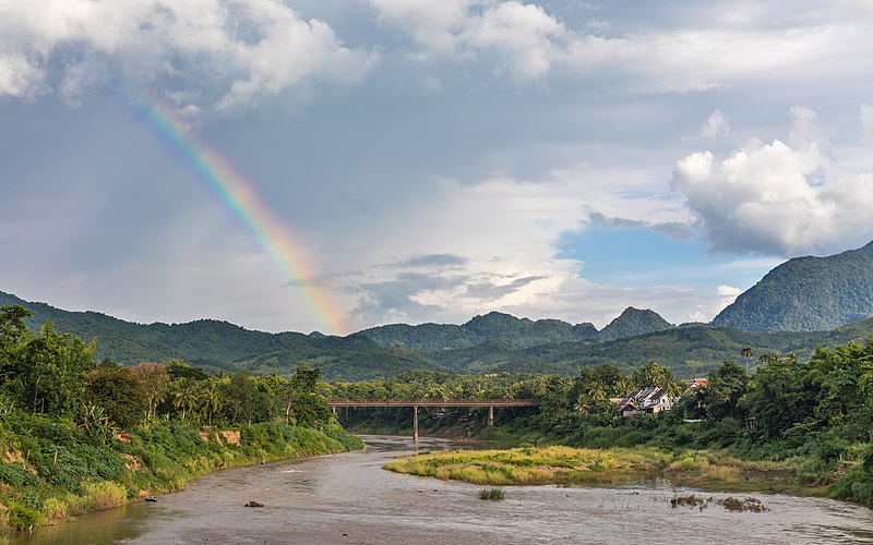
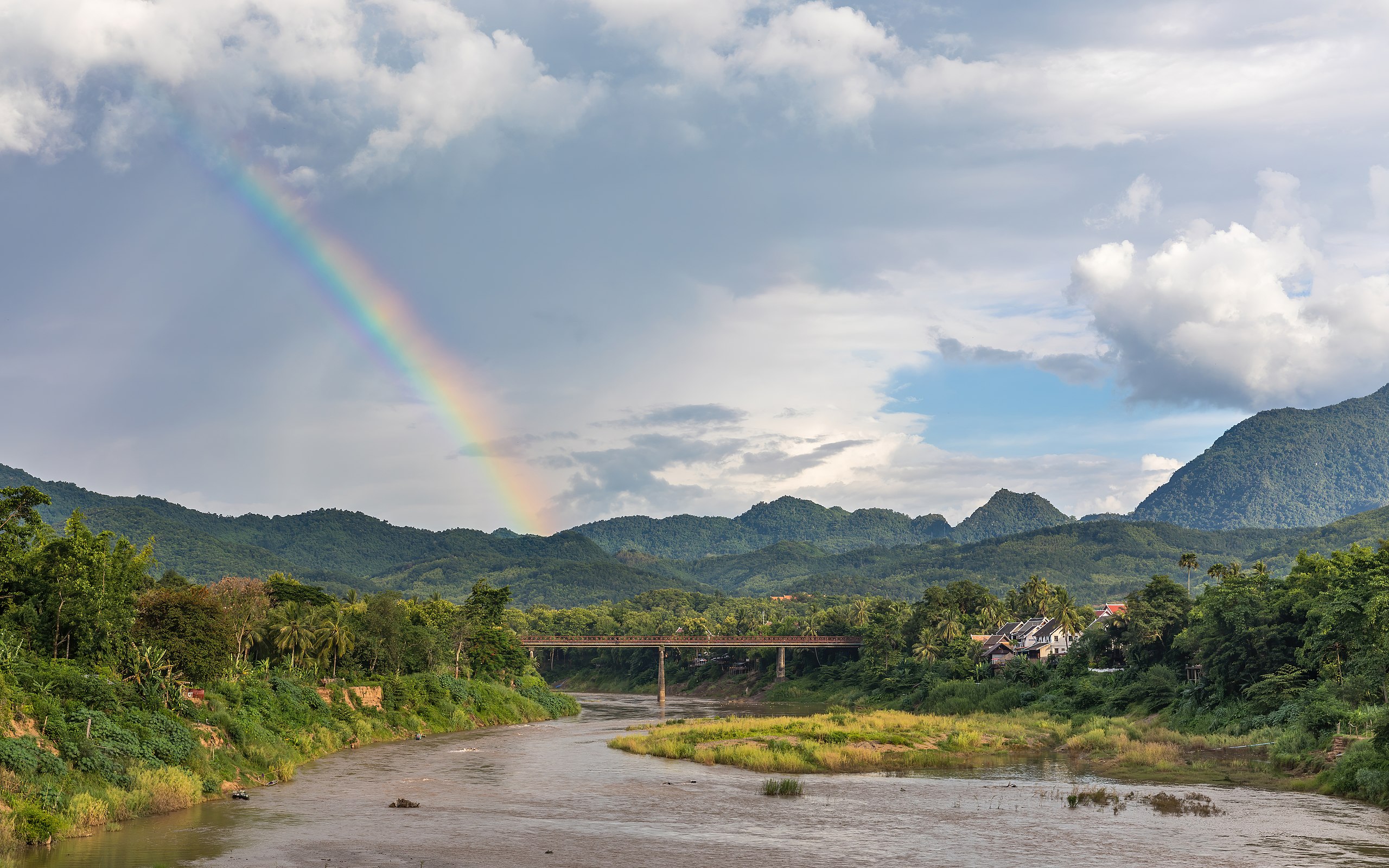
English: Landscape with rainbow and the Old Bridge over the Nam Khan river, Phetsarat road, in Luang Prabang, Laos.
Français : Paysage avec arc-en-ciel et le Vieux Pont au-dessus de la rivière Nam Khan, rue Phetsarat, à Luang Prabang, Laos.
Tiếng Việt: Phong cảnh với cầu vồng và cây cầu bắc qua sông Nam Khan, đường Phetsarat, ở Luang Prabang, Lào. |
Date | |
Source | Own work |
Author | Basile Morin |
Camera location | 19° 53′ 30.51″ N, 102° 08′ 21.34″ E | View this and other nearby images on: OpenStreetMap | 19.891807; 102.139260 |
---|
|
This image was selected as picture of the day on Vietnamese Wikipedia.
|
Licensing
I, the copyright holder of this work, hereby publish it under the following license:
This file is licensed under the Creative Commons Attribution-Share Alike 4.0 International license.
- You are free:
- to share – to copy, distribute and transmit the work
- to remix – to adapt the work
- Under the following conditions:
- attribution – You must give appropriate credit, provide a link to the license, and indicate if changes were made. You may do so in any reasonable manner, but not in any way that suggests the licensor endorses you or your use.
- share alike – If you remix, transform, or build upon the material, you must distribute your contributions under the same or compatible license as the original.
Items portrayed in this file
depicts
some value
19°53'30.505"N, 102°8'21.336"E
16 June 2018
0.01 second
50 millimetre
image/jpeg
File history
Click on a date/time to view the file as it appeared at that time.
Date/Time | Thumbnail | Dimensions | User | Comment | |
---|---|---|---|---|---|
current | 10:43, 18 February 2021 | 6,666 × 4,166 (10.12 MB) | wikimediacommons>Basile Morin | Uploaded own work with UploadWizard |
File usage
The following page uses this file:
Metadata
This file contains additional information, probably added from the digital camera or scanner used to create or digitize it.
If the file has been modified from its original state, some details may not fully reflect the modified file.
Camera manufacturer | Canon |
---|---|
Camera model | Canon EOS 5D Mark IV |
Author | Basile Morin |
Copyright holder |
|
Exposure time | 1/100 sec (0.01) |
F Number | f/8 |
ISO speed rating | 50 |
Date and time of data generation | 17:31, 16 June 2018 |
Lens focal length | 50 mm |
Latitude | 19° 53′ 30.5″ N |
Longitude | 102° 8′ 21.34″ E |
Altitude | 305.6 meters above sea level |
Orientation | Normal |
Horizontal resolution | 94 dpc |
Vertical resolution | 94 dpc |
Software used | Adobe Photoshop Lightroom 6.0 (Windows) |
File change date and time | 10:31, 18 February 2021 |
Exposure Program | Manual |
Exif version | 2.3 |
Date and time of digitizing | 17:31, 16 June 2018 |
APEX shutter speed | 6.643856 |
APEX aperture | 6 |
APEX exposure bias | 0 |
Maximum land aperture | 3 APEX (f/2.83) |
Metering mode | Pattern |
Flash | Flash did not fire, compulsory flash suppression |
DateTimeOriginal subseconds | 17 |
DateTimeDigitized subseconds | 17 |
Color space | sRGB |
Focal plane X resolution | 1,866.6666564941 |
Focal plane Y resolution | 1,866.6666564941 |
Focal plane resolution unit | 3 |
Custom image processing | Normal process |
Exposure mode | Manual exposure |
White balance | Auto white balance |
Scene capture type | Standard |
GPS time (atomic clock) | 10:30 |
Satellites used for measurement | 7 |
Receiver status | Measurement in progress |
Measurement mode | 3-dimensional measurement |
Measurement precision | Poor (3.8) |
Geodetic survey data used | WGS-84 |
GPS date | 16 June 2018 |
GPS tag version | 0.0.3.2 |
Serial number of camera | 088053003158 |
Lens used | EF24-70mm f/2.8L II USM |
Date metadata was last modified | 17:31, 18 February 2021 |
Unique ID of original document | 20F25DBEA8562F26E36C8D5B31740D15 |
Keywords |
|
City shown | Luang Prabang |
Province or state shown | Luang Prabang Province |
Country shown | Laos |
Code for country shown | LA |
IIM version | 4 |