File:AlexanderIsland.png
Jump to navigation
Jump to search
No higher resolution available.
AlexanderIsland.png (243 × 334 pixels, file size: 33 KB, MIME type: image/png)
This is a file from Wikimedia Commons. Information from its description page there is shown below.
Commons is a freely licensed media file repository. You can help, but they'd probably rather you didn't. |
Summary
| Description |
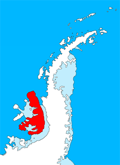
English: Outline map of the Antarctic Peninsula showing Alexander Island.
Drawn by me (User:Grutness) based on File:Ant-pen_map.png by Giovanni Fattori. |
| Date | 2 July 2011 (original upload date) |
| Source | Transferred from en.wikipedia |
| Author | Original uploader was Grutness at en.wikipedia |
Licensing

|
Permission is granted to copy, distribute and/or modify this document under the terms of the GNU Free Documentation License, Version 1.2 or any later version published by the Free Software Foundation; with no Invariant Sections, no Front-Cover Texts, and no Back-Cover Texts. A copy of the license is included in the section entitled GNU Free Documentation License. |
Original upload log
The original description page was here. All following user names refer to en.wikipedia.
- 2011-07-02 09:27 Grutness 243×334× (34005 bytes) Outline map of the Antarctic Peninsula showing [[Alexander Island]]. Drawn by me (User:Grutness) based on [[:File:Ant-pen_map.png]] by Giovanni Fattori.{{GFDL}}
File history
Click on a date/time to view the file as it appeared at that time.
| Date/Time | Thumbnail | Dimensions | User | Comment | |
|---|---|---|---|---|---|
| current | 18:36, 9 July 2011 | | 243 × 334 (33 KB) | wikimediacommons>MGA73bot2 | {{BotMoveToCommons|en.wikipedia|year={{subst:CURRENTYEAR}}|month={{subst:CURRENTMONTHNAME}}|day={{subst:CURRENTDAY}}}} {{Information |Description={{en|Outline map of the Antarctic Peninsula showing en:Alexander Island. Drawn by me (User:Grutness) |
File usage
The following page uses this file: